Hydrogeophysical Imaging and Characterisation
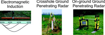
The research group “Hydrogeophysical Imaging and Characterisation” focusses on the high resolution hydrogeophysical imaging and characterisation of the unsaturated and saturated zone using high-frequency electromagnetic geophysical tools, electromagnetic induction (EMI) and ground penetrating radar (GPR).
Electromagnetic tools are important for a wide range of hydrogeological investigations because of their noninvasive character and the fairly quick measurement acquisition. The obtained electromagnetic parameters, electrical conductivity and relative permittivity, are of great interest to determine soil properties, e.g., clay content, porosity or hydrologic state variables including soil water content.
Our research focusses on modeling and inversion tools that explicitly take into account the electromagnetic wave propagation characteristics and return high resolution images of quantitative medium properties. Our main research areas are:
Full-waveform inversion of off-ground, borehole, and surface GPR
Conventional tomograms provided by standard ray-based methods have limited resolution, primarily because only a fraction of the information contained in the radar data is included in the inversion. Higher resolution radar tomograms can be derived by using full-waveform inversion schemes that take into account much of the recorded trace and exploit the full vector wavefield.
More
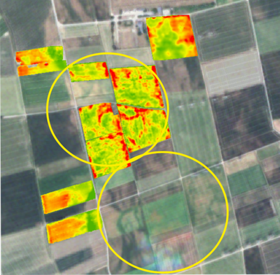
Large-scale multi-configuration EMI characterization
Due to recent system developments, large-scale EMI measurements are possible due to the fast measurement speed and easy coupling with GPS systems. The availability of multi-channel electromagnetic induction (EMI) systems that measure at several receiver coils enables a simultaneous sensing of electrical conductivity over different depth ranges
More
Quantitative multi-layer conductivity inversion of multi-configuration electromagnetic induction measurements
A new calibration method that uses electrical resistivity tomography (ERT) inversion eliminates instrumental shifts which often occur in EMI data and returns quantitative apparent electrical conductivity values. Using different orientations, different coil offsets, and different frequencies, different sensing depths are obtained that are used for a multi-layer inversion.
More
Dispersion inversion of GPR data recorded across surface waveguides
Strong contrasts occurring in the shallow subsurface due to precipitation events, freezing, and thawing events, etc. can result in the presence of electromagnetic waveguides that cause dispersive GPR data. These data need to be inverted using dedicated inversion approaches.
More
Georadar Rundtisch Gespräch (GPR Roundtable meeting)
The GPR roundtable meeting is aimed at scientists, engineers and georadar/GPR users with the aim of constructively discussing and analyzing new knowledge and insights. The goal of the workshop is to spread knowledge about GPR technology and its use, as well as, to provide a unique possibility to participants to exchange ideas about the advances in their work and discuss their results. Results are presented in German and English
More
BSc/MSc Thesis and Fellowship/Internship projects:
Large-scale EMI and GPR hydrogeophysical soil characterization
Weathering front characterization with EMI and GPR in Chile
Full-waveform inversion
Multi-layer multi-configuration EMI inversion
Inversion of waveguide dispersed GPR data
Please contact me for more details about the current projects
Contact

Prof. Dr. Jan van der Kruk
Head of research group "Hydrogeophysical Imaging and Characterisation"
- Institut für Bio- und Geowissenschaften (IBG)
- Agrosphäre (IBG-3)
Raum 3037
Fax: +49 2461 612518
Faculty of Georesources and Materials Engineering
Links:
IDEA League Joint Masters in Applied Geophysics
The Near-Surface Geophysics Section of the Society of Exploration Geophysicists (SEG)